
Welcome to the Coronation Country Park

After numerous unsuccessful applications from a developer to build housing on the site, these 48 acres of ex-farmland were transferred to RWB Town Council ownership in January 2025. RWBET are working with the town council grounds team to manage the land, which opened as the Coronation Country Park, preserving and enhancing the site for the benefit of residents and visitors - humans and animals!
The site is bordered by the canal, with spectacular views across the countryside to the south. But, with little council funding, it relies heavily on volunteers, donations and sponsorship to deliver the project. RWB Environment Trust members are represented on a Steering Group that has been set up to guide the development.


Our volunteers have been working with council grounds staff to plant new trees (including a small community orchard), improve access, restore ponds and ditches, and hedgerows across the park. This is a big, new and exciting project for the Trust and a great opportunity for our town and for the environment.
Before becoming a park, this site was used as farmland, like much of the surrounding area.
Looking at satellite imagery over the last 25 years shows you how the town has grown around the land.

Satellite image dated 31/12/2002

Satellite image dated 16/03/2014

Satellite image dated 18/05/2025
Satellite image dated 31/12/2002
Plans for Improving the Country Park
A key objective is to make the country park more accessible for residents & visitors to enjoy the benefits of the wide open space, fresh air and amazing views. But, at the same time, we want to manage the area with a "light touch" to preserve the countryside landscape and improve habitats to increase wildlife diversity. A development plan that strikes this balance has been agreed with the Town Council, covering improvements to the country park (see red circles on diagram below). A good start was made on some of these during 2025 (our first year of operation):

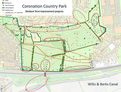
Current Map of the CCP and Future Improvement Plan
Short-Term (by the end of 2025)
-
Undertake baseline ecology survey/investigations
-
Confirm maintenance regime
-
Improve boggy paths
-
Additional tree planting
-
Commence a ponds and ditches refurbishment programme
-
Reintroduce meadow mowing regime
-
Add rustic benches for key vistas
-
Reduce areas of bramble
-
Set up connections with wider community - schools, local groups, businesses
-
Install information boards
Long-Term (2028 onwards)
-
Develop plans for canal and countryside connections
-
Set up a community management group in place of the Steering Group
-
Investigate the benefits of formal Country Park designation (or similar)
-
Develop plans for a “Gateway Centre” and car parking
Medium-Term (2026-2027)
-
Additional tree planting
-
Additional ponds
-
Additional benches
-
Integrate the Dairy Hill area into the country park
-
Convert some tracks to all-weather paths and improve access from the canal
-
Cycle path across the park joining up the Dairy View and Evening Star estates
-
Consolidate trees, ditches, bramble and meadow-mowing into annual maintenance
-
Undertake archaeological excavations
-
Initiate a programme of events and regular activities
-
Explore potential for connecting with the canal, old Wiltshire Council depot and countryside beyond
-
Secure substantial funding for projects
The park's name reflects the town’s royal connection and the initiation of the project to bring it under community ownership during the year King Charles III was crowned in Westminster Abbey.